
Volcanic Fury
Following a massive undersea volcanic eruption near the Pacific island nation of Tonga, authorities are trying to establish contact with residents and assess how badly homes and property were damaged. The world is holding its breath as authorities say they’re not sure whether there will be casualties.
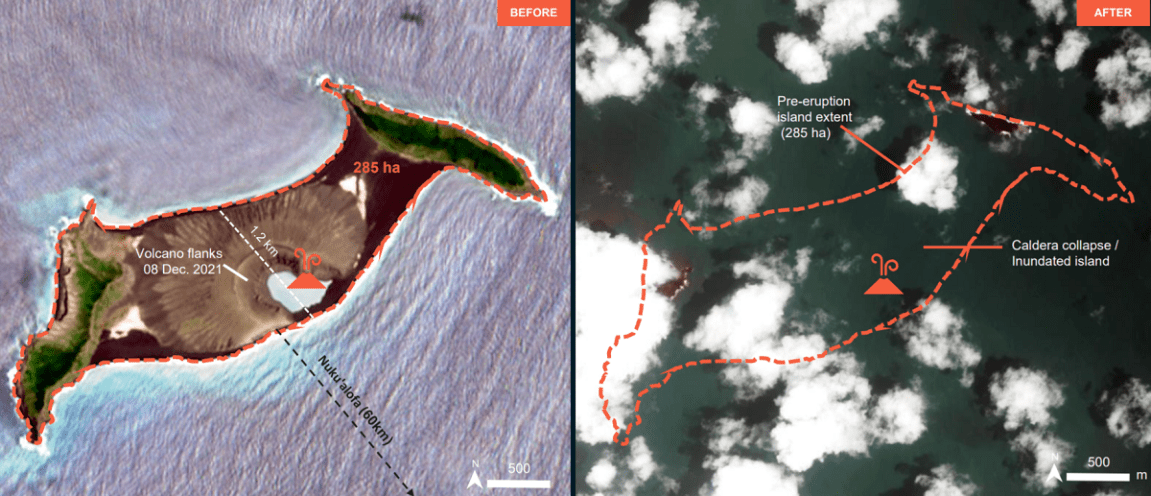
As this piece previously reflected, there was initially speculation that the blast had expanded the island where the Hunga Tonga volcano is located. But new imagery from the United Nations Satellite Centre shows that the opposite is likely true — damage from the eruption appears to be so severe that nearly the entire island is no longer visible from above.
More imagery shows similar devastation.
Will It Stick?
In 2015, the same undersea volcano erupted and formed the Hunga Tonga island, although according to satellite imagery company Planet Labs, scientists thought it would erode away within months. However, it stuck around for some time. In fact, just last month a smaller eruption increased the size of the island by what experts believe to be nearly 50 percent.
“Imagery captured the first clear view of the new island structure on 2 January 2022,” Dan Slayback, a research scientist at NASA’s Goddard Space Flight Center in Maryland, had told Planet Labs prior to the most recent eruption. “Comparing PlanetScope imagery from mid-December, before the most recent eruption began, the surface area of the island appears to have expanded by nearly 45 percent due to ashfall.”
We’ll be watching the latest news and research to come following the eruption — though the most important story, of course, is whether people in the area are safe.
Updated throughout with new information.
More on the undersea volcano: Hey Kids, Wanna See Satellite Footage of a Volcano Violently Erupting?