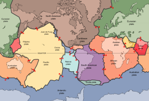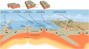

Plate tectonics is the theory used to explain the structure of the Earth’s crust and many of the associated phenomenon. The rigid lithosphere is split into 15 major plates that slowly move on top of the underlying asthenosphere (plastic upper mantle), and this science studies the faulting and folding of the crust along the various boundaries: convergent, divergent and conservative. Thought the concept was only considered to be widely accepted in the 1960s, it was first coined by the German geophysicist Alfred Wegener back in 1915.
His first ideas came form noticing that the continents fit together very closely along the continental shelves- the coastlines would have been subject to erosion and weathering. In addition, during several expeditions on either side of the Atlantic he analysed the rock type and fossil distribution and found a very significant match between the East and West. Distinct 2 billion year old rock types on either side of the ocean appeared to line up perfectly when you put the continents together. In terms of fossils, the water reptile Mesosaurus was found in a band across South Africa and southern South Africa, and the land reptile Lystrosaurus was uncovered right from India, across Africa and into Antarctica.
Other contributors to the theory included Harry Hammond Hess, who conducted a series of surveys of the ocean floors around the world, and found a remarkable pattern that showed up a series of trenches and ridges – with the rocks becoming progressively older when you move away from the ridges. From this he developed his ideas of sea floor spreading that was driven by underlying magma rising from the mantle and pushing the crust outwards at ridges where it would then be spread, and this offered a reasonable explanation for Wegener’s findings.

His work was then reinforced by British geologists Frederick Vine and Drummond Matthews, in what is known as paleomagnetism. It is based on the theory that the Earth’s magnetic poles wander or switch over millennia and the magnetic compounds in the molten rock align with the current magnetic field. These solidify and effectively preserve the direction and latitude of the poles at that time in a series of stripes parallel to the oceanic ridge. The findings supported Hess’ theory that the oceanic crust was created at the oceanic ridges and then split in half.
But there is also much more evidence that come from climatic changes in the Earth’s surface. Glacial striations (rock ‘scars’) and the till deposits have been found in areas of the world that are far from either of the poles. These striations also show the direction in which the glacier was moving out from – and it was been found to be from southern Africa. If the southern land masses are aligned at the South Pole, these striations perfectly line up with one another. We can also look at the rock distributions around the world that are a result of climatic zones. Britain is now in a temperate latitude surrounded by a cold ocean and seas – but its geology doesn’t suggest this. We can find lots of limestone and coal, but these only form in warm shallow seas, hence we can deduce that the UK must have once been positioned much closer to the equator.
In recent decades our technological and scientific advances have enabled us to explore and map much more of the Earth’s surface accurately, and understand what is going on using computer simulations and models. What we have found complies with the theories created by those in the last century, and we know more information about the mechanisms behind the various formations and plate boundaries between the major tectonic plates.

Constructive plate boundaries come in two forms; oceanic ridges and rift valleys. At oceanic, the oceanic crust is created where the mantle convection spreads the sea floor, this creates areas of low pressure and the plastic mantle forms a mafic (which is rich and magnesium and iron) that effuses onto the sea floor. This idea supports what we see around the world, in places such as Mid-Atlantic Ridge, the Galapagos Ridge and the East Pacific Rise. The tectonic activity may be in the form of submarine volcanoes and fissures, or the magma may build up into islands that break the surface such as Iceland’s main land mass, and its smaller volcanic islands of the coast (such as Surtset). These eruptions aren’t violent, but instead are characterized by a nearly continuous stream of runny magma that forms a gentle slope away from the vent or fissure.
Rift valleys are emergent plate boundaries within continents, such as the East African Rift Valley. Brittle crust fractures as sections move apart and areas begin to drop down in sections parallel to the faults with high scarps, often marked by a series of steps. The rift valley in Africa stretched up the north what it has widened into the Red Sea and the Gulf Of Arabua; eventually the sea will also innundate the East African Rift Valley. This matches with what we observe, as there are several volcanoes around that include Kilimanjaro and Erta Ale.
Subduction zones add in the next explanation to Hess’ ocean floor conveyor belt mechanism, being the region in which the crust destroyed. Here denser oceanic crust sinks beneath the light continental plate into the upper mantle where the intense heat melts it down into an andestic magma. The collision produces a deep sea trench and often a fold mountain range, and the angle at which the crust subducts may change the characteristics of the area. For example the high volcanic activity to the south of Chile relative to the north is thought to be a a result of the oceanic crust subducting at a steeper angle.
Here at subduction boundaries the high friction and melting between the two plates produces some of the most powerful earthquake and volcanoes in the world. 75% of the entire world’s active and dormant volcanoes, as well as the majority of the large earthquakes are found in a 40,000km ring around the Pacific Ocean called the Ring of Fire. Old ocean floor basalts are less dense than the mantle and so rise up through fissures and burning until they reach the surface as volcanoes that erupt with a felsic magma. Fold mountains are composed of sea floor ocean deposits in an accretionary prism, as well as high silica rocks, metapmorphic rocks and intermediate/acidic rocks. This is due to the combination of both crustal types, and the intrusion of more complicated magma.
This correlates to the seismic and volcanic events across the world, as the thicker magma has a higher explosivity and produces steeper volcanoes but this unpredictable and violent eruptions. Classic examples include the Mt. St. Helens eruption of 1980, where the active stratovolcano is part of the Ring of Fire and erupted as the most economically damaging volcanic event in US history. Also the Mt. Pinatubo eruption in 1991 in the Philippines, which was the 2nd largest terrestrial explosion of the century, ranked at level 6 on the Volcanic Explosivity Index. Seismic examples include the Japanese earthquake of 2011, a magnitude 9.0 undersea mega-thrust, being the most powerful earthquake to ever hit Japan and the 5th most powerful ever recorded. The 6th largest ever recorded was the Chilean earthquake of 2010 where the 8.8 earthquake struck along a 700km, and was felt by 80% of the population of the country.
Other plate boundaries include collision zones, where the two continental plates or two oceanic plates collide to form mountain chains or island arc respectively. When two continental plates are pushed together across a shrinking ocean, the crust is too buoyant to be subducted and so they rise up into mountains. Here there is no volcanic activity because magma is unable to move up through any cracks, and the mountains may include marine geology such as limestone or fossils. Between two oceanic plates one may be marginally denser than the other and so one is subducted into an arc shape with a volcanic island chain, often with a deep-sea trench beside it. The subduction also produces frequent, shallow-deep focus earthquakes that may be immensely powerful, such as those in Japan.
Conservative plate margins occur when two plates are sliding past one another parallel or nearly parallel, they may be moving in the same direction with different speeds or different directions. Here no crust is destroyed or split apart and so there is no upwelling of magma from the mantle – hence earthquake but the absence of volcanism. But the friction from sliding or locking and breaking free of the plates results in the release of energy in the form of earthquakes such as the San Andreas Fault in California and the Alpine Fault in New Zealand. However, the movement of plate tectonics fails to explain several different observed phenomena, including the intra-plate volcanic activity of Hawaii and Yellowstone National Park.

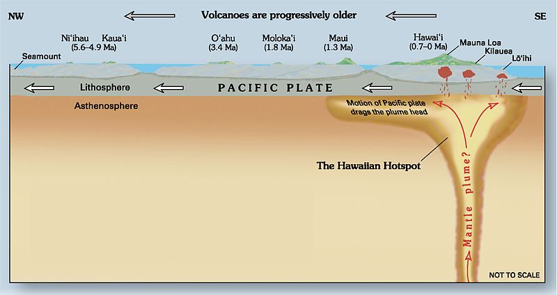
John Tuzo Wilson offered an explanation by putting forward the existence of ‘hot spots’. These are broad dome of magma up to 1,000km across within the mantle that may generate result in magma breaking to the surface through fissures and cracks. The old explanation for these is superheating at the core-mantle boundary generating a more powerful convection current which becomes molten in the lower pressure of the upper mantle. But recent evidence has not tallied up with this deep-rooted explanation. Alternative suggestions say that the movements of crustal plates create areas of low pressure over the plastic mantle, or possible that ancient, partially melted subducted oceanic slabs turns molten in low pressure. These would rise as a much shallower plume no deeper than 400-600km.
Hot spots are what are suspected to be situated stationary beneath Hawaii and Yellowstone to give an answer to the intra-plate volcanism. The Yellowstone Caldera, measuring 55 by 72 by 1km, is thought to be a supervolcano hiding a magma chamber containing up to 600km^3 of molten rock (this would make it more than 5 times above the supervolcano classification). The caldera formed during the past 3 supereruptions, 2.1mya, 1.3mya and 0.64mya, implying a cycle of around 600,000-700,000 years. Hawaii is different and thee faster movement of the Pacific plate over the hot spot has resulted in an island chain of volcanoes that increase with age as you travel further from the current active one. Hot spots are also thought to explain the Deccan Traps in northwest India, where a series of basaltic floods are though to have occurred, creating one of the largest volcanic features on Earth – being up to 2000m thick in places.
So hot spots explain volcanism away from plate boundaries, but another anomalous finding was the extinct volcanoes and activity across places such as Europe. There appeared to be evidence of extinct volcanoes in Scotland, and old rift site between Germany and France, and many features of intrusive igneous rock such as the Whin Sill across northern England. It was found that 65 million years ago – the same time that North America, Greenland and Europe were still connected – a major hot spot formed beneath the crust that caused the continental riding and large amounts of magma to be intruded into the crust. This opened up the continents to create the Atlantic Ocean, which is still expanding outwards from the Mid-Atlantic Ridge. Iceland appears rather anomalous, as the island formed very quickly and there isn’t anything similar anywhere else along the ridge. Therefore it is thought that Iceland is combination of the constructive plate boundary erupting magma and a hot spot.
Plate tectonics theory does help our understanding of the distribution of seismic and volcanic events as by understanding the various plate margins we can then understand what is happening across the Earth’s crust. It offers a partial explanation to not just where the events occur, but also how they happen, their characteristics and possible a foresight for predicting their effects. But the theory is by no means a unifying one, as we have discussed the current and relic features of volcanism that do not appear to follow plate boundaries. In conclusion, the theory of plate tectonics is useful as it enables us to better predict and understand events as well as to protect those living in a disaster zone. But it is important to pull together several mechanisms associated with the Earth’s structure in order for us to completely understand what is going on.