
When you consider plate tectonics we often think of hot magma bubbling up from the Earth’s mantle, and we remember the vast assortment of pictures that we’ve seen–images featuring hundreds of active volcanoes spewing forth smoke and lava, and the devastation that always follows. Gargantuan explosions that blow-off the caps of mountains and lava flooded landscapes dominate our imaginations. So it may surprise you to know that the vast majority of the molten rock that rises up into the Earth’s lithosphere never reaches the surface. Instead, it cools and solidifies to form coarser-grained igneous rocks beneath the ground.
Western Europe (and Britain in particular) is a very interesting case study to look at when considering the impact of magma intrusions. 65 million years ago saw the start of the Paleogene Period; a time when North America, Greenland and Britain were all connected to Europe as a single large continent. It is thought that, at this time, a major hot spot developed beneath the crust, and this caused continental rifting (the splitting apart of a land mass). The split created a new plate boundary and opened up the area for the Atlantic Ocean to form, while also being responsible for the unusual volcanism in Northern Britain.
The magma intrusions that formed range in size from many kilometres to just a few centimetres, and many have contributed to the surface topography and geomorphology across Britain. Each different landform has characteristic features that relate to the nature of the cracks and joints of fissures within the country rock (the rock native to an area). Scientists have no method of detecting the intrusions until the rock above has been eroded – unless there is doming of the rock above. In this scenario, the high pressure build-up of magma being forced into the crust pushes the rock upwards. This technique has actually been used to study the Yellowstone super volcano.
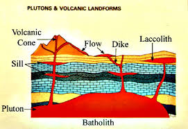
Batholiths are the largest species of magma intrusion. They can reach hundreds of kilometres across, and are classified as having at least 100km² of top exposure. They are formed as a consequence of a vast amount of magma that is built up by a series of smaller intrusions occurring in the same place over time, which we call a “layered intrusion.” These enormous structures are commonly generated during a period of mountain buildings, such as the Alpine orogeny in Europe (which formed the Alps). As plates collide the effects aren’t just around the boundaries but can cause widespread buckling of the crust much farther away.

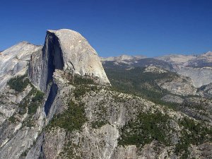
This buckling pushes the crust beneath deeper into the upper mantle, where it gets hot enough to be melted down. However, the result of melting down crustal rock produces a thick, acidic form of magma that isn’t able to flow easily through the crust. As a result, it cools inside slowly to form an enormous intrusion of high silica content granite rocks. There is actually another phenomenon called “contact metamorphism,” which is caused by the large surface area in contact with the sedimentary rock; this heat and pressure produces metamorphic rocks such as marble. Possibly the most famous batholith is Half Dome, in the Yosemite National Park (pictured here).
Though this isn’t the only way that magma may be intruded into the crust; the other methods involve the structure of the overlying rock itself. Sometimes the magma is able to force its way between the layers of country rock so its sits parallel, or concordant, with the existing strata – we call this particular landform sills. They vary in thickness from centimetres, to a hundred metres, and so they cool much faster than batholiths. There are some very famous examples of these that include The Great Whin Sill that runs across northern England. The angle at which it protrudes from the ground made it the perfect site for the Romans to build Hadrian’s Wall in order to keep out the Scottish, as well being the place where Britain’s highest waterfall, High Force, cascades over.
Dykes are similar to these, but fundamentally different. Instead of pushing in between the layers of rock, the magma cuts through it by utilising the pre-existing cracks and weakness. What is left is effectively a wall of rock positioned perpendicular to the country rock that, like sills, ranges in width from a few centimetres to several kilometres. The high pressures involved as magma is forced into the crust often create a complex of cracks that are also intruded, producing many dykes and an intrusive pattern called a dyke swarm. The most famous British example is the Kildonan dyke swarm on the Isle of Arran, western Scotland.
The intrusive landforms don’t rest here either, there is another branch. You can picture lopoliths and laccoliths as the spatial opposites of each other. Lopoliths are usually concordant with the country rock and lenticular in shape, with a central depression caused by crustal sagging. They are typically built from low-silica basaltic/andesitic magma under low pressure, and it is this low pressure that causes the crust to sag downwards. However lopoliths are very rare, as most magma that gets intruded has a more complex chemistry, and so is thicker in nature.

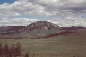
Laccoliths are very similar to sills but form close to the surface and dome the overlying rock upwards as a consequence of high pressure magma. A feeder dyke beneath the laccolith supplies high viscosity magma that does not move easily through the crust and so gives the high pressure characteristic. The domed country rock will eventually be weathered away to expose the laccolith as a very resistant hill, while the surrounding region is wore down! Laccoliths are the only intrusive feature that scientists can try and detect the formation of because of the big doming impact on the country rock!
So much of the landscape that we travel through every day is the product of tectonic activity that we almost take for granted the immense forces that formed it! Try think twice next time you’re walking along the road, you have no idea what is going on beneath your feet…