
Around The World Tour
Since its launch into space in 1999, the Advanced Spaceborne Thermal Emission and Reflection Radiometer (ASTER) has been taking pictures of Earth. In 16 years, ASTER has collected images covering nearly 99% of the Earth’s surface. Aboard the NASA Terra spacecraft, it is owned separately by the Japanese, who never released the images to the public.
But now, the images are finally made public and can be viewed on the ASTER Gallery Map. There are approximately 2.95 million archived satellite images, so it required a lot of sorting to find the best photos – and NASA takes some beautiful photos.
So, here is a handy catalogue of some of the best.
Appearing as if a child spilled melted crayon wax everywhere, this photo captured the Andes Mountains using an infrared camera that detected changes in surface temperature, materials, and elevation.
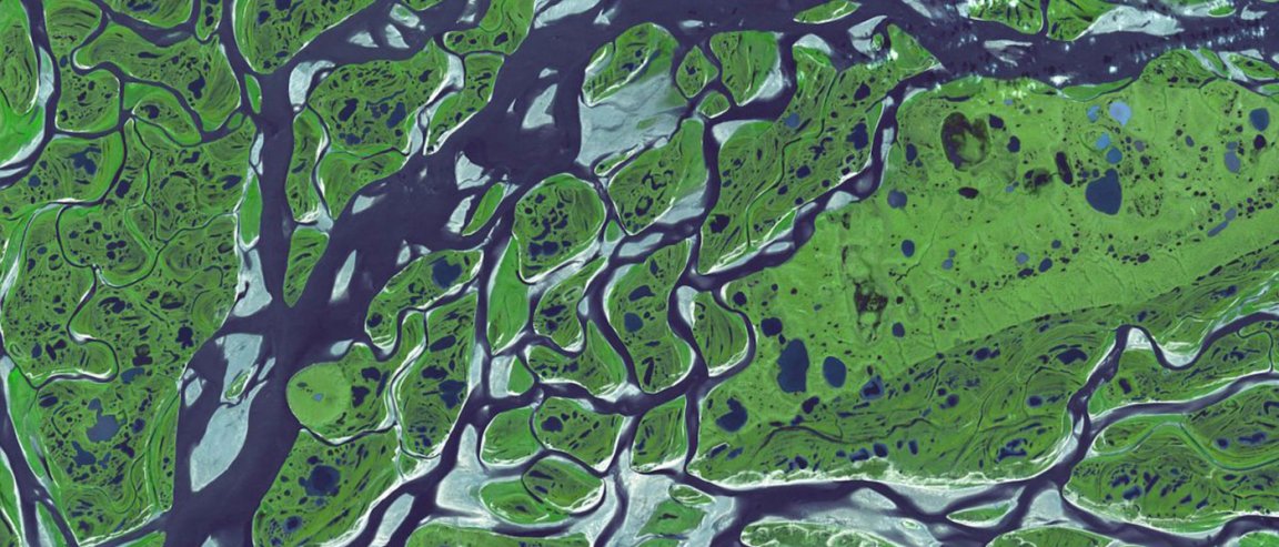
This ASTER image is the most popular in the gallery. It’s a photo of Manaus, Brazil, at the junctions between the Amazon River and the Rio Negro Rivers. The Rio Negro is the dark current seen flowing at the north portion of the river, and it gets its dark pigment from tannin.
This is an image of the Ferdinand and Isabela islands that belong to the Galapagos Islands in the Colón Archipelago. The islands are made up of active volcanoes, which can be seen above.
The Oresund Bridge spans 10 miles across the Oresund Strait connecting Sweden to Denmark. It’s a combined motorway and railway bridge that goes partially underwater. There’s a manmade island in the middle of the strait that helps make the trip.
This side-by-side display shows the affects of the crippling drought in North Korea. The left image shows the amount of vegetation (in red) in 2002, compared to the bare fields marked in deep blue caused by the drought in 2015 (right image).
Near the center of the Lighthouse Atoll is the Great Blue Hole. You can see its surrounding carbonate reef. It’s a World Heritage Site and Belize National Monument. Jacques Cousteau took the calypso on a journey into the hole in 1972 to examine the stalactites inside.
This alluvial fan in China is formed from deposits of gravel, sand, and salt. It forms the southern border of the Taklimakan Desert in China’s XinJiang province. The blue nerves are small streams of actively flowing water.
This view shows 400 bridges connecting 120 islands that make up Venice, Italy. The only traffic that moves through the city is by boat.
On the west coast of Ecuador, south of Guayaquil, wetlands are being converted into shrimp farms. The top image shows 143 square kilometers of converted wetlands in 1991. The bottom image shows a staggering 243 square kilometers converted by 2001. 83% of the original wetlands are gone.
The McMurdo Dry Valleys in Antarctica sees very little snowfall. Scientists have confirmed that this landscape is the closest representation of terrestrial Mars.
This infrared image shows the southwest part of the Malaspina glacier in Alaska. The light blue hue is marked by snow and ice. Yellow-orange and green hues represent dense vegetation, while orange represents the less vegetated areas. These images are being used to track glacial movement and size over time.
The Anti-Atlas Mountains in Morocco were formed about 80 million years ago as a result of colliding tectonic plates. This infrared image shows the folding of different rock types such as limestone, sandstone, gypsum, and granite.
If you look closely enough, you can see the only ship that was using the Suez Canal in Egypt. This photo was taken in 2000.
This complex system of dikes, dams, canals, bridges and locks holds out the North Sea on the southwest coast of the Netherlands. The rivers have created an enormous delta of waterways and islands over time.
In this image, you can visibly see the damage caused by the Hayman forest fire, which destroyed more than 90,000 acres of land in Colorado in 2002.
The Kondyor Massif in Eastern Siberia, Russia, is surprisingly not a volcano. It is a perfect circular igneous intrusion that was formed from the crystallization of of molten magma under the Earth’s surface. The magma then rose to the surface and cooled. There’s a river that flows from the center.
In glacial times, the Dagze Lake in Tibet used to be much larger, marked by the many fossil shorelines on the outer rim. Climate change caused the lake to dry up and the region to become more arid.
The eruption of Mount Etna in Italy lasted almost a month in 2001. The bluish smoke in the bottom right corner shows the sulfur dioxide plume coming from the summit.
This infrared image captures the extremely stark contrast between the US-Mexico border in California. The lush farmland found on the Southern California side (top) is marked by red differing from the barren Mexico border.
This image shows the Escondida open-pit mine located in Chile’s Atacama desert. The landscape has been transformed for mining purposes. The mine currently produces 127,000 tons/day of ore comprised of copper, gold, and silver.