

Plate tectonics is the theory used to explain the structure of the Earth’s crust and many of the associated phenomena. The rigid lithosphere is split into 7 major ‘plates’ that slowly move on top of the underlying asthenosphere (mantle). This branch of geology studies the faulting and folding of the crust along the various boundaries; convergent, divergent, subduction, and conservative. The concept of Plate Tectonics was first coined by the German geophysicist Alfred Wegener back in 1915, but several ideas of continental drift date back many years before. Today we almost take for granted our knowledge of how the Earth’s crust shifts and regenerates on a continual cycle; but the theory of plate tectonics wasn’t widely accepted until the 1960s!
In his time, Alfred Wegner (1880–1930) was known for his work in meteorology and polar research, but today he is best remembered for his additions to the development of continental drift theory. His first ideas came from noticing that the continents of the Earth fit together very closely – but not along their coastlines (this is because of erosion/weathering). He noticed that, at the continental shelves, all the large Earth masses fit nearly perfectly. Wegener went on several expeditions on both sides of the Atlantic Ocean to analyze rock type and fossil distribution, and he found a very significant ‘matching’ between the East and West sides of the Atlantic Ocean. It was shown that 2 billion year old rocks were continuous from one continent to another when placed side by side. This also applied to fossil records, including the fresh-water reptile, Mesosaurus (found across South Africa and southern South America), the land reptile Lystrosaurus (found in a band across current India, Antarctica, and central Africa).
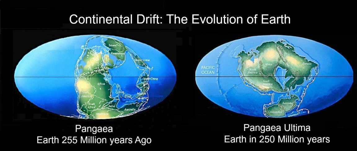
At the time, some of the most prominent theories were that species evolved independently from one another, or that they swam across oceans to get to their current locations. The best received theory was the idea that ‘land bridges‘ rose and fell randomly during Earth’s geological history. These enormous portions of land, which would spontaneously rise and fall out of the ocean floor, were suggested to exist long enough to that they gave flora and fauna enough time to move around the globe. However, Wegener deduced that the continents must have once been connected in a single super continent (Pangaea), and from this mass the continents drifted apart. He presented his ideas to the German Geological Association in 1912, and wrote a book titled ‘The Origin on Continents and Oceans’ in 1915. What let Wegener down was his proposed mechanism; he suggested that the movement was a result of centrifugal force from the Earth’s rotation, or tidal effects from the moon.
Wegener’s last contribution was just before his death, in which he found that shallower oceans were younger. It wasn’t until a while later that another geologist, Harry Hammond Hess, also saw similar observations in the ocean floors. During his service in the US Naval Army in WWII, Hess had access to SONAR technology, which he used to map the sea floor in a series of surveys. He found two things. First, he found what are now called “Mid Ocean Ridges” (e.g. The Mid Atlantic Ridge that runs vertically along the ocean floor and is thousands of kilometres in length) that were up to 1.5km higher than surrounding crust. Second, he discovered that (conversely) the deepest parts of the ocean were actually very close to continental margins in the Pacific. These trenches extended down over 11km (e.g. The Marianas Trench off the coast of Japan). From this discovery he deduced that the Atlantic must be expanding from its center as molten rock from the mantle underneath seeps through fissures along the Mid Atlantic Ridge. This explained why the rocks became progressively older as he moved away (instead of a uniform 4.5 billions years) and why there is so little sediment deposits found on the ocean floor (see the image below for clarification).

Hess decided that the explanation for his findings must be that not only were the continents moving, but the sea floor was also spreading in a ‘conveyor belt’ system. His idea was based on mantle convection. At the ridges, hot magma rises up after being heated by the core. At the crust, it hardens and becomes the newest part of the sea floor. As magma continues to rise in the convection current, the oceanic crust is pushed aside so that more seeps through the gap. The outward movement of magma underneath the lithosphere effectively ‘pushes’ it outwards – expanding the oceans. Hess claimed that, if rock is being pushed out of the mantle and hardening into crust, it must also be destroyed somewhere else (about 3 km² destroyed and created a year) – this was his explanation for the deep trenches at the edges of continental shelves.
Here, he suggested that the dense oceanic crust is subducting below the less dense continental plates, where it is then to be melted and recycled within the mantle. In 1962 he published his book ‘History of Ocean Basins.” This, combined with his fantastic speaking skills, generated a major leap forward towards the acceptance of Plate Tectonics and continental drift. One of the reasons Hess was more successful in convincing geologists, when compared to Wegener, was that he said the continents were actually just carried along as the ocean floor spread. Wegener had said that the continents pushed through the ocean floor as they moved, which was deemed impossible by critics. Therefore, Hess’s model of the reasoning behind continental drift was more easily accepted.
Very soon after, new findings were published that further reinforced Hess’ ‘sea floor spreading’. This is known as “paleomagnetism.” Two British geologists worked with this idea – named Frederick Vine and Drummond Matthews from Cambridge University. Vine was actually a PhD student under Matthews at the time of their research. Paleomagnetism is based on the idea of ‘polar wandering’ and ‘polar switching’. This means that the Earth’s magnetic field moves over long periods of time, or completely reverses its direction at different intervals. Magma contains a large concentration of magnetite and iron, so that (in its molten state) the ions are free to align themselves with the Earth’s magnetic field. When the magma cools and hardens into the basalt ocean floor, it acts as a record, preserving the direction and latitude of poles at that time. In the 1950s, scientists developed a way of measuring this, and so Cine and Matthews’ work involved looking at the magnetic patterns in the ocean floor. What they found was a very obvious symmetrical pattern of ‘stripes’ parallel to the ocean ridge. In addition, when these rocks were dated, they were discovered to have the same age at equal distances on either side of the ridge. These findings completely supported Hess’ theory that the oceanic lithosphere is created at mid ocean ridges, and then split in half and moved outwards. This idea is know known as the Vine-Matthews-Morley Hypothesis.

There is also much climate evidence supporting continental drift, most notable of which is glacial activity. Alfred Wegener investigated this field and found an anomaly in the Permo-Carboniferous ice sheet that was found through glacial till deposits to have once covered all the southern major plates. If the continents were in their current positions about 300 million years ago, this glacier would cover most of the globe and extend above the equator. But geologists have found no evidence of glacial action in the northern hemisphere at this time, and instead say the climate was warm and even tropical. Also, glacial striations (essentially ‘cut marks’) found in rocks from the movement of this ice sheet show that the direction in which it was moving was outwards from a central point in southern Africa. If the continents are set adjacent to one another at the south pole, these striations line up with each other.
This aided Wegener’s theory that the continents were once all joined as a single landmass. He also reconstructed the distribution of climate zones at different times in the past, and compared this to the distribution of rock types found across the globe. For example, Britain is now in a temperate latitude surrounded by a cold ocean and cold seas, but its geology doesn’t suggest this. We can find lots of limestone (e.g. The White Cliffs of Dover) and coal, and these only forms in warm, shallow seas. So the UK must have once been positioned much closer to the equator. Also, in the Antarctic, you can find coral reefs, suggesting also that Antarctica was also once in a much warmer climate belt. Wegener suggested that the poles remained stationary and that the continents changed their positions relative to the poles, which we know know is not accurate (actually, both the continents and poles continuously shift in position).
After huge contributions from several pioneers over the last century, all the evidence suggests that the theory of Plate Tectonics and continental drift is accurate. The Earth’s crust is constantly changing, driven by heat from the Earth’s core. Even today, the continents are still moving – set to reform a super-continent again in 250 million years as ‘Pangaea Ultima’.