
Extremely Dangerous
Terrifying imagery reveals the might of Hurricane Milton.
The hurricane, which emerged as a tropical storm in the Gulf of Mexico over the weekend and is expected to make landfall on the western coast of Florida Wednesday evening, was declared an epic Category Five hurricane yesterday after rapidly intensifying in the gulf.
The scale of the storm is staggering: wind speeds have topped a treacherous 180 miles per hour with sustained gusts of over 200 miles per hour. Over one million Floridians were urged to evacuate.
Meteorologists and storm experts, meanwhile, have taken to social media to detail the magnitude of the severe weather event.
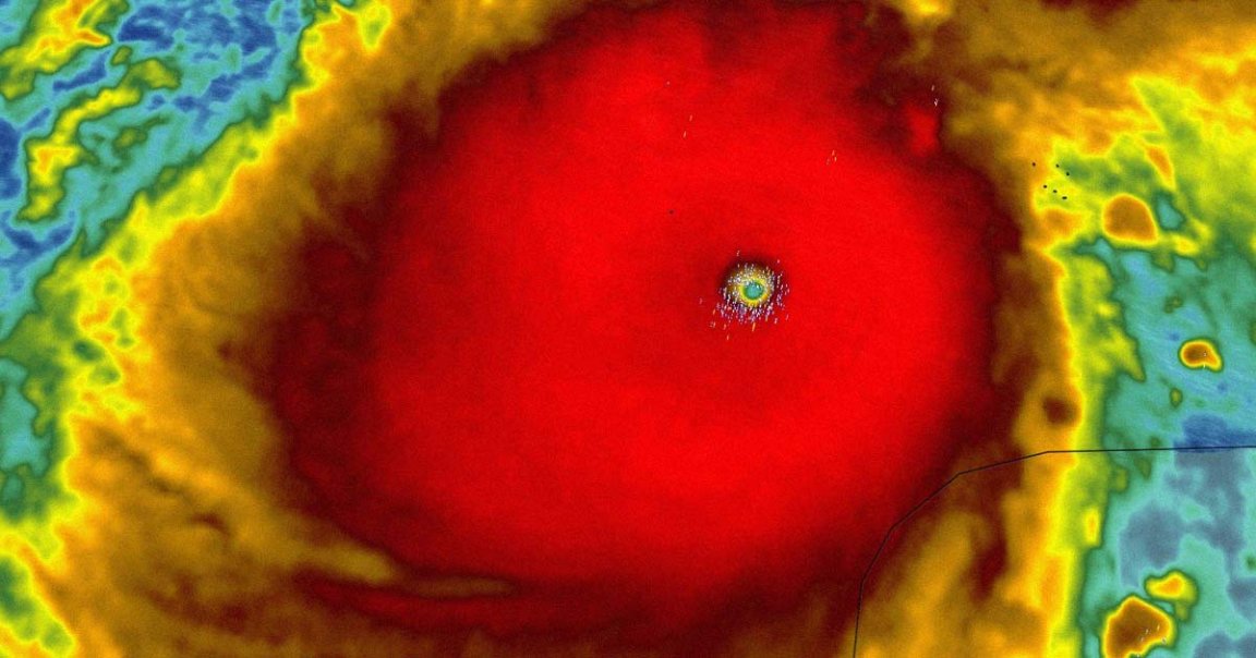
“This is nothing short of astronomical,” reads a widely-shared warning from Orlando’s weeknight meteorologist Noah Bergren on X-formerly-Twitter.
In his post, Bergren shared astonishing radar images revealing Milton to be what amounts to a massive red blob, swallowing the entire map. Red and maroon coloring on a weather radar map signals torrential rainfall, flash flooding, and hurricane conditions.
“I am at a loss for words to meteorologically describe [to] you the storm’s small eye and intensity,” Bergren wrote. “This hurricane is nearing the mathematical limit of what Earth’s atmosphere over this ocean water can produce.”
Low Pressure
Milton has since fallen to a still very dangerous Category 4 storm, and could — emphasis on could — be relegated to a Category 3 by the time it makes landfall in Florida late Wednesday evening. (A Category Five storm is the most extreme type of hurricane currently recognized.)
The storm comes barely a week after deadly Hurricane Helene wreaked havoc in Appalachia, causing unprecedented destruction in western North Carolina and Tennessee — areas historically safe from hurricanes.
Though Milton is expected to weaken slightly as it approaches the shore, it shouldn’t be underestimated. As The New York Times points out, 2005’s Hurricane Rita lowered to a Category 3 intensity before barrelling into Louisiana and Texas. But Rita was nonetheless wildly destructive, causing billions of dollars in damages and killing more than 100 people.
Milton has similarly reached historic levels of strength. As of 8 PM last night, when those wild radar images were taken, the storm recorded the fifth lowest central pressure reading for any Atlantic hurricane on record. That makes the storm the fifth most powerful in the Atlantic’s recorded history, per Newsweek.
Government agencies are continuing to warn Floridians of the storm’s ferocity.
“While fluctuations in intensity are expected,” reads the National Hurricane Center’s latest advisory, “Milton is forecast to remain an extremely dangerous hurricane through landfall in Florida.”
Local officials are also warning people to evacuate the area as soon as possible.
“I can say, without any dramatization whatsoever, if you choose to stay in one of those evacuation areas, you’re going to die,” Tampa Mayor Jane Castor told CNN yesterday.
More on hurricanes: Deadly Hurricane Beryl Supercharged by Climate Change, Experts Say